The Albion Gold Mining Company was only one of many companies that operated in the Terawhiti area, although it probably expended the greatest amount of money and effort to find gold. Gold mining was a major story of nineteenth-century New Zealand and Terawhiti is an example of this ‘gold fever’; but, in this case, it was an unsuccessful field. Despite its lack of payable gold, the Terawhiti mines gave employment to miners, packers, ship owners and indirectly to storekeepers and tradesmen for a few years in the 1880s during an economic depression.
The battery remains are approximately three kilometres up Black Gully from Oteranga Bay, located on the right of the road in a flat area of the valley floor. The incline tramway and the mine are on the hill to the left of the road, west of the battery site. The battery, built in 1883, was housed in a substantial wooden and corrugated iron building. The machinery was powered by a steam boiler, and was manufactured in Wellington. As the mine was 300 metres west on the hill above the battery site, a system of tunnels and tramways was built to bring the ore to the battery. A bullock road was also constructed to the site from Oteranga Bay on the south coast, where the heavy machinery was shipped in. Due to the unsuccessful nature of the gold field the battery was only used for three crushings (the two berdans only being used during the last crushing) and the company’s failure, combined with the topography, meant that most of the equipment was not removed from site.
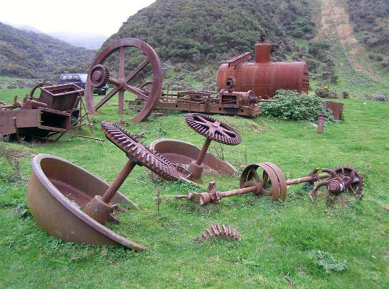
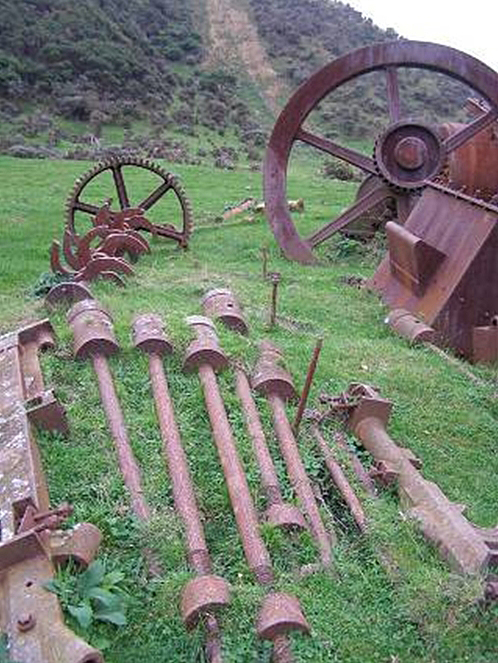
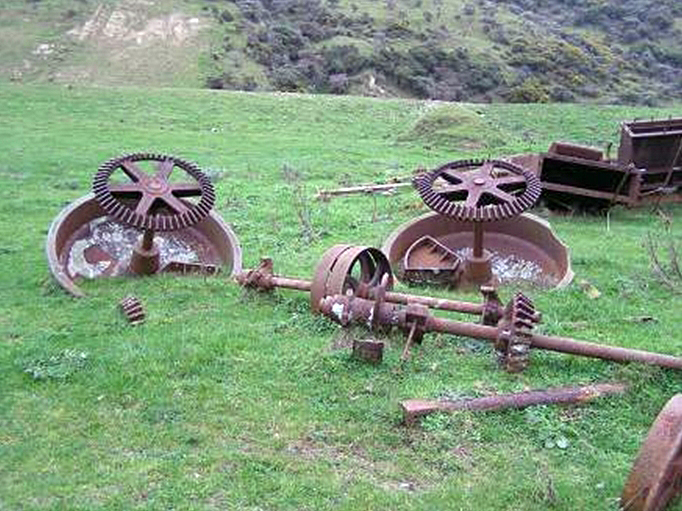
Although the battery building has long gone, the main elements of the battery equipment are still in place: the boiler, the engine, the flywheel and cam shaft, two stamper boxes (each contained five stampers), the two berdans; and the stampers lie in the grass behind the cam shaft. The mine entrance, the cutting for the incline tramway and the embankment near the battery site are also visible. The site therefore has the potential to provide knowledge of the gold mining period of New Zealand history at a particular point in time; especially in the lower North Island, which is not usually associated with gold mining. The battery remains show the technical process of quartz mining and crushing for gold extraction in the 1880s, prior to the implementation of the more efficient cyanide extraction process. The Albion Gold Mining Company Battery and Mine Remains present a fairly intact snapshot of gold mining in the 1880s.
Location
List Entry Information
Overview
Detailed List Entry
Status
Listed
List Entry Status
Historic Place Category 2
Access
Private/No Public Access
List Number
9032
Date Entered
2nd May 2013
Date of Effect
2nd May 2013
City/District Council
Wellington City
Region
Wellington Region
Extent of List Entry
Extent includes part of the land described as Pt Sec 62 Terawhiti District (RT 321565), Wellington Land District and the archaeological remains and structures associated with the Albion Gold Mining Company thereon, including the remains of the battery (NZAA site Q27/112), embankment, mine manager's house (NZAA site Q27/120), incline tramway and mine, and their fittings and fixtures. The extent does not include Transpower's fibre optic cable which is located near the road. (Refer to map in Appendix 1 of the registration report for further information).
Legal description
Pt Sec 62 Terawhiti District (RT 321565), Wellington Land District.
Location Description
The Terawhiti area is a block of steep hill country on the south-west tip of the North Island, west of Wellington City. The Albion Gold Mining Company Battery and Mine Remains are located on private land in Black Gully, also known as Oteranga Stream Valley. Permission to access the site must be granted by the landowners. GPS Location data of the Albion Battery: E 1737520 N 5429959 +/- 3m, taken at the base of the flywheel. An embankment associated with the transport of quartz from the mine to the battery is located at GPS coordinates E1737486 N5429963 (+-3m) at its eastern end. The Albion mine manager’s house was just across the stream to the north of the battery: GPS coordinates approximately E 1737516 N 5430010.
Historic Significance
Historical Significance or Value Gold mining was a major story of nineteenth-century New Zealand. Gold rushes brought people, investment and ancillary services to an area. It was a popular activity particularly in economic downturns when the lure of gold was strongly felt as a way back to prosperity. The work was difficult and often carried out in isolated places. Many men tried, but failed, to make their fortune. Terawhiti is an example of this ‘gold fever’; but, in this case, it was an unsuccessful field. Places such as these are mostly forgotten in the New Zealand story of gold, but they should be remembered for telling us that not all gold mining ventures were successful.
Physical Significance
Aesthetic Significance or Value The setting of the Albion Battery remains is visually dramatic. Access to Terawhiti Station is from South Makara Road, and from the station gates the route winds over ridges and valleys before descending to Oteranga Bay on the south coast and then up the valley (Black Gully). The Battery remains are surrounded by hills to the north, west and east. The landscape is rugged and isolated (access was more difficult prior to the wind farm development in the 2000s); which has contributed to the survival of the remains. However, since at least the 1920s the remains have been visited and photographed by tramping parties. They are a striking industrial feature in a rural landscape. Archaeological Significance or Value The mining activity carried out in this area by the Albion, and other companies, in the 1880s mean the whole area has high archaeological values. These have been recognised in the New Zealand Archaeological Association site recording scheme, which notes four sites on the relevant land parcel (the battery, the mine manager’s house, one end of the Bullock Road and the Caledonian mine – Q27/112, Q27/120, Q27/127 and Q27/113) but other sites are also known and not recorded. For example, the Albion mine, embankment and tramway sites. The Albion Battery Remains are the most visible remains from the gold-mining activity in the Terawhiti area. It is also highly likely that sub-surface material exists. The remains have the potential to tell the story of the unsuccessful attempt at gold mining in this location. The extent of registration follows the land parcel and is based on visible remains. Technological Significance or Value The battery remains show the technical process of quartz crushing for gold extraction in the 1880s, prior to the more efficient cyanide extraction process. Due to the unsuccessful nature of the gold field the battery was only used for three crushings (the two berdans only being used during the last crushing) and the company’s failure, combined with the topography, meant that most of the equipment was not removed from site. They are illustrative of the industry at that time. The Albion battery is the best preserved known example of a battery between the West Coast of the South Island and Thames/Coromandel. It is significant because most of the battery equipment is present and as it was hardly used it represents a snapshot of 1880s technology, unlike more successful gold fields where machinery was used for longer periods and often needed replacing.
Detail Of Assessed Criteria
(a) The extent to which the place reflects important or representative aspects of New Zealand history Gold mining was an important part of the nineteenth century (and in some places, the twentieth century) New Zealand economy. The gold rushes also increased the population as well as the demand for agricultural and other products. The Terawhiti goldfield experienced this only briefly and did not in the longer term contribute to the economy. The Albion battery remains, tramway and mine represent the effort that went into finding gold in a fairly remote and inaccessible place, and the hopes of many Wellingtonians that gold would be their economic saviour in a time of depression in the 1880s. (c) The potential of the place to provide knowledge of New Zealand history The site has the potential to provide further knowledge of the gold mining period of New Zealand history in the mid-1880s, through archaeological methods. This is especially important as a site in the lower North Island, a region which is not usually associated with gold mining. Terawhiti is representative of a gold mining story that is not told as often as the story of the successful fields. All of the sites and features present at the Albion site combine to form a significant archaeological landscape. (f) The potential of the place for public education Public access to the sites is limited as it is on private land; however access can be arranged with the owners, Terawhiti Farming Company, or a paying tour undertaken with Rover Tours. The restricted access has helped preserve the remains in situ. The land owners would like to see the battery remains protected from the elements and preserved. With only a little interpretation it would be easy to tell the story of the gold mining period in this isolated location. (k) The extent to which the place forms part of a wider historical and cultural complex or historical and cultural landscape The Albion Gold Mining Company was only one of many companies that operated in the Terawhiti area, although it was one of the few that expended significant amounts of money and effort to find gold. Other mine sites are in the vicinity of the Albion. Also, further to the east are other gold mining sites, mostly connected with the earlier (c. 1870) period of mining. The whole Terawhiti area also has sites associated with Maori occupation (10 are registered historic places), World War Two, the Cook Strait power cable North Island terminal at Oteranga Bay, and with the pastoral farming stations that own most of the land. There is an urupa at Oteranga Bay and karaka groves associated with Maori occupation near the road that leads from the bay to the battery site.
Construction Professional
Biography
The Wellington firm of S. Luke and Company (also known as Luke and Sons and Williams, and S. Luke and Sons), had a foundry approximately where the Opera House now is in Manners Street (Luke’s Lane), Wellington. Samuel Luke purchased the business of Gilchrist and Waters (est 1876) in 1879 after the Luke family emigrated from Cornwall, and established the company. He had four sons including William, and Sir John-Pearce (1858–1931), who was Mayor of Wellington and a Member of Parliament. Another son, Charles Manley Luke (later Sir Charles) (1857–1941) worked in the firm’s office at the time, and was also Mayor of Wellington. Luke’s foundry was one of the largest in Wellington, occupying one and a half acres (0.6 hectares). The company specialised in ship building, boilermaking, cooking ranges and iron and brass work, securing notable jobs such as building the Castlepoint and Cape Palliser lighthouses, eleven hydraulic cranes for the Wellington Harbour Board, and the SS Matai, at the time the largest steamship built in New Zealand. The company also built the battery engine and boiler for the Albion Gold Mining Company Battery and Mine Remains (List No. 9032) and supplied decorative cast iron-work for the Carterton Band Rotunda (List No. 3962). In 1913 Sir Charles Manley Luke retired from business and the firm was purchased by J.J. Niven and Co.
Name
Luke and Sons and Williams
Type
Engineer
Construction Details
Start Year
1883
Type
Original Construction
Description
Battery, with berdans installed, used for the last time to crush ore, by the Golden Crown Company.
Start Year
1886
Type
Other
Description
Battery building burnt down
Finish Year
1903
Start Year
1902
Type
Partial Demolition
Description
Terawhiti Dykes Company dismantled the stampers and removed some equipment to its gold prospecting site in Yankee Valley
Start Year
1912
Type
Other
Description
Farm track at the west side of the valley, cutting into the embankment, was widened and improved as part of Meridian Energy’s wind farm development.
Start Year
2008
Type
Other
Construction Materials
Wood, corrugated iron, cast and plate iron, leather belts drove the flywheel and stampers.
Terawhiti is a block of steep, rugged hill country on the south-west tip of the North Island, west of Wellington City. Maori settlement on the south-west coast was concentrated in the larger bays and at the mouths of the larger streams – Karori and Waiariki. Maori occupation possibly began prior to the fifteenth century. The Wellington area was successively populated primarily by people of Kurahaupo waka descent, including Ngai Tara, Rangitane, Muaupoko, Ngati Apa and Ngati Ira (who are generally accepted as the most recent). The Waitangi Tribunal’s report on the Wellington claims refers to these as ‘Whatonga-descent peoples’ since all claimed descent from the early explorer Whatonga. Tribes from Taranaki began raids into the area from 1819, followed by more permanent migrations in the 1820s, although it was common to go back and forth during most of the nineteenth century. Ngati Tama settled at Ohariu, Ohau and Oteranga bays as well as at places around the harbour. An estimated 200 Ngati Tama were in the Wellington area, including the south west coast, at 1840. Te Atiawa also had interests at Te Ika a Maru Bay and on the south coast. The survey of the Wellington District began after the arrival of the New Zealand Company in 1839. A Port Nicholson land order for ₤100 gave its owner a one acre town section and 100 acres of rural land, plus a first class passage. The survey therefore divided the rural hinterland into 100 acre lots, although large areas remained unsurveyed for some years. Within these boundaries, reserves were to be set aside for the various tribal groups. A subsequent alteration of the New Zealand Company’s western boundary in 1844 took it out to the west coast at Pipinui Point (between Makara and Porirua) and the 1848 Crown grant to the company gave the total area within these extended boundaries as 209,247 acres. At a rough estimate, this extension added 50,000 acres, including the Terawhiti area. In 1850 the New Zealand Company collapsed and as a result its lands became vested in the Crown. Marine terraces on parts of the south coast, and the valleys provided areas for farming, which European settlers began in the 1840s. Around 1845 James McMenamen (a 23-year old Irishman) drove a small herd of cattle for William Barnard Rhodes around the south coast to the Waiariki Stream area, near Tongue Point. By about 1853 McMenamen had begun buying land in the area. Descendants of James and Hannah McMenamen still own Terawhiti, Te Kamaru and Te Marama stations, which together comprise most of the land west and south of the village of Makara. Gold Mining in New Zealand Gold discoveries in California in the late 1840s and New South Wales and Victoria in the early 1850s attracted both miners from New Zealand and interest in finding gold here. In 1852 alluvial gold was found in the Coromandel, Terawhiti and Collingwood; at Moutere in 1856, the Buller River in 1859 and in Otago (Gabriel’s Gully) in 1861. The major producing areas for gold in New Zealand became Otago, the Coromandel/Thames area and the West Coast of the South Island. The usual pattern was first individuals panning for alluvial gold, followed by quartz mining, which required greater mechanisation and more capital. Gold mining attracted people, infrastructure and support services. Gold Mining at Terawhiti Alluvial gold was first found at Terawhiti (Waiariki Stream) in November 1852, thought to be by a local Maori, Honetana Tatu (Jacky Dunn). Specimens of gold from Terawhiti were shown at a London exhibition in 1862. But not until 1869 did a ‘mini rush’ occur; this was on the eastern side of the Terawhiti area. With an improving economy in the 1870s the lure of gold was forgotten for a time, until economic circumstances worsened at the end of the decade. The gold mining sites in the Terawhiti area generally date from the 1850s to the 1910s, although a prospecting licence was issued as late as 1971. They include a range of features including mines, tracks, shafts, tailings, and machinery. However, due to the lack of success in finding much workable gold at Terawhiti, the area seldom rates a mention in most general accounts of gold mining in New Zealand. For example, in Salmon’s Gold Mining in New Zealand, the only mention of Terawhiti is: ‘Even at Cape Terawhiti near Wellington, where traces of gold had been noticed as early as 1862, a battery was set up in the eighties to crush deposits of ore. Work was soon abandoned, and the rusting machinery served no purpose save to surprise lonely trampers in the coastal hills.’ He may have had in mind the photograph of the remains of the Albion battery boiler that featured in the New Zealand Centennial publication Making New Zealand, which included a tramper in the image. The history of gold mining at Terawhiti is, however, well described by James Brodie. Terawhiti is representative of a gold mining story that is not told as often as the story of the successful fields. Albion Gold Mining Company The Albion Prospecting Association had been formed in October 1880 to prospect for new reefs and work an old claim from the earlier mining period. The association was formed into a public company, Albion Gold Mining Company, in February 1881. The discovery in early 1881 of gold-bearing quartz on Black Mountain (Terawhiti Hill) led to the most substantial period of mining at Terawhiti, in the west of the area, which had not been prospected before. The Albion Company soon negotiated with the quartz discoverers, and with the landowners, Terawhiti Station, to be able to stake a claim. Black Mountain soon also became known as Albion Hill. Installing the battery In May 1882 the company took out a lease of one acre in Black Gully from the McMenamen estate for the erection of a quartz crushing machine. The contract to build a 25 horsepower horizontal steam engine and boiler to drive the 10-stamper battery was signed in July that year and Luke, Sons and Williams began the work. They were a Wellington engineering firm who had built small ships, cranes, and other gold mining equipment. The stampers of 750 pounds weight each (about 341 kg) and some other battery parts had been made by Langlands of Melbourne and it is likely these were bought second-hand. Lukes’ contract included fitting up the whole as a going concern on the site in Black Gully. A bullock road also needed to be constructed up the valley from Oteranga Bay to the battery site. In June 1882 a geological report from Alexander McKay had been received – surprisingly, after such a short operating time, some of the shafts had fallen in or were in a state of disrepair, but the company’s focus was on getting the battery and tramway built. The mine manager was replaced in July 1882 and over the next several months the new manager ensured the tunnels were re-timbered, tracks were laid, trucks made for the tramway, a ‘paddock’ (meaning an area for holding extracted ore) was excavated and a blacksmith’s shop was built. Ninety tons of quartz were ‘to grass’ – excavated and stored in the paddock. The battery was finished at the end of 1882 and Luke and Sons and Williams assembled and tested some of the equipment at their foundry. It was Samuel Luke’s eldest son William who was in charge of construction work at the site. The steamship Moa transported the equipment to Oteranga Bay in several stages and it took from February to May 1883 to cart the machinery into place. Terawhiti Station undertook the carting job. As the Albion mine was high on the hill and the battery located 1,000 feet (circa 304.8 metres) below in the valley, a tramway also needed to be constructed to get the ore down from the mine. Tenders were let for the tramway construction in March 1883. The battery was housed inside a weather-board clad building which had a large inverted V-shaped roof of corrugated iron, necessary to accommodate the 10 raised stampers. It had a 30-foot chimney. The battery boiler was fired with wood, except for the test for its government certificate when coal was used. By June 1883 the battery was ready but the tramway was not. Early in July the Albion Company decided to import a pair of berdans from Melbourne – the original design of the battery had omitted these. However, there was a long delay and they were only used for the last crushing in 1886. Operation of the battery The Golden Crown mine wished to use the battery and therefore undertook the first crushing. This began on 21 July 1883 and finished on 11 August. The first newspaper report of the crushing reported the manager as saying the returns ‘must be regarded as exceedingly satisfactory’. The gold found from 51 tons of quartz was worth around ₤260 – in itself the return was good, but scarcely covered the expenses of the extraction and getting the ore to the battery. During the Golden Crown crushing a safe was sent out to the battery, the door of which was later found in the early 1960s by Bruce McFadgen and Hilton Tonks near the remains of the mine manager’s house and is now in the Te Papa Tongarewa Museum of New Zealand collection. There was some criticism of the machinery – and some miners got some gold by panning the battery tailings. After some alterations to the battery, the Albion Company began crushing its own quartz on 25 August 1883. The quartz-crushing operation required the quartz to be shovelled a number of times, from the mining of quartz high on Terawhiti Hill where the rock was first shovelled into trucks. These were pushed along a horizontal tramway and emptied into a holding paddock, from where it was shovelled into the incline trucks. At the end of the incline, the rock was dropped into a shaft that connected with a horizontal tunnel from where it was fed into trucks that were pushed across an embankment and wooden trestle to be tipped beside the battery. From here it was shovelled into the stamper boxes. The operation of the stamping mill or battery is described by the Thames Miners Guide 1868, as consisting of a series of heavy iron stamps each of which is alternately lifted by means of a cam and then let fall on to the quartz to be crushed. The ore is shovelled into the battery box and water is also introduced. The crushed ore is generally led over blankets spread on shallow troughs or sluices. A large proportion of the gold becomes entangled in the fibres of the wool, which are replaced every quarter hour or so. The crushed quartz and water either from the battery or the berdans if these were installed is next led through troughs passing over copper plates surfaced with amalgam. The plates are prepared by first washing them with nitric acid then rubbed with mercury. To remove the amalgam the plate is heated over a fire; the amalgam softens and may be easily scraped off. The gold is then retrieved from the amalgam by heating. In the late 1880s/1890s an improved method of extraction using cyanide was introduced, but this was after mining had finished at Terawhiti. A drawing of a battery shows the stampers supported by a heavy timber framework. The battery operation required as many as eight men, and to give a better sense of it, Brodie adds: ‘We can imagine the bustle of men carrying in wood from the stockpile, stoking the boiler, the engineer watching the engine looking out for hot-spots and keeping an eye on the stampers. We can sympathise with the hands loading trucks in the dim light of candles at the end of the tunnel into the hill behind and with the gang shovelling quartz into the stamper boxes.’ End of the Albion Company In September 1883 the company’s finances were critical and the company was voluntarily wound up and a new company formed – the Albion Extended Gold Mining Company. In October 1883 results from the crushing were very poor – barely covering the costs. The Mining Manager and most staff were laid off. The company’s first half-yearly meeting in January 1884 heard a report on the ‘recent unsatisfactory crushing’ and various people, including the mining and battery managers were blamed. However, the Inspecting Engineer of Mines said of batteries in 1886 that the ‘working expense and wear and tear are so costly that low-grade quartz cannot be worked to pay with the present appliances’. At its January 1884 meeting, as the company was ₤600 in debt, it decided to cease operations meantime. The company was finally wound up in 1886. The Albion Gold Mining Company invested more energy and money in providing the means for extracting and crushing quartz than did any other company. Despite this, they also failed – for the same reasons the other companies did: the intermittent occurrence of good gold-bearing quartz due to earthquake faulting, the lack of critical expertise and the inefficient means of extracting gold from quartz then available, and the pressures generated by the share market in buoying up hopes beyond realistic expectations. But Brodie concluded that on balance it was a very worthwhile gamble. Most of the shareholders were Wellingtonians and the mining gave employment to miners, packers, ship owners and indirectly to storekeepers and tradesmen during an economic depression. If it had been a success the economic effects on Wellington would have been substantial. Last crushing The machinery stayed unused until the end of 1885 when the Golden Crown Company leased it, brought it into working order and installed the berdans. Their crushing began in May 1886 and took three weeks. The gold recovered realised only about a quarter of the ₤800 it had cost to make the battery operational and carry out the crushing. ‘Gold fever’ – related services and activities The popularity of the ‘gold fever’ in the early 1880s in Wellington is shown by frequent newspaper reports, the use of Pigeon Express (carrier pigeon) to bring news from the mines, and in activities such as the Wellington Amateur Dramatic Club’s performance of ‘The Very Witty Diggings’ on 18 February 1881. The government steamer Hinemoa also took many members of both Houses of Parliament on an excursion to the gold fields on 11 August 1883. A post office was opened there in October 1883 – it survived until early 1885. By 1882, Makara resident Wilhelm Sievers had built additions to his house for accommodation and for selling alcohol, calling it The Miners’ Arms. This building was demolished in 1977 as the land is now owned and used by the Karori Golf Club. Fred Dowsett also supplied the mines with bread and groceries. He built a store on the gold fields, which was completed in mid-August 1883 (NZAA site Q27/119). It is not known how long his store operated but he said he lost over ₤1000 from the venture. Terawhiti station also sold meat to the miners. Sheds and whares, although numerous, were sparsely spread over the field. There were various tracks in the area that miners could use to access the mines, although they were not always in good condition. Sievers’ Track began behind Wilhelm Sievers house in South Makara Road and was used in the 1869–72 period and then widened and extended in 1881 to access the Phoenix Mine (the extension is usually called the Phoenix Track – NZAA site R27/285). McLean’s Track, made in 1886, gave access from Makara to the northern end of the gold fields (NZAA site R27/286). Under The Crown Grants Act 1866 the Crown had the right to proclaim (for a limited time period) a one-chain wide road through a section without paying compensation. The Government responded to pressure for access by carrying out surveys of road lines and proclaiming them so the miners had legal access to the mines. The Bullock Road (NZAA site Q27/127) constructed from Oteranga Bay to the Albion mine battery to bring in the heavy equipment was not intact at the start of wind farm construction (Project West Wind). Meridian Energy Limited also later brought its wind turbines in from Oteranga Bay and constructed a new road up the valley from Oteranga Bay. Where possible this was located several metres east of the Bullock Road, to protect what remained of it. Dr Bruce McFadgen noted that the Bullock Road near the Albion battery was originally ‘constructed’ by moving boulders and debris out of the way; given this and that it had been subsequently modified as a farm track, there were no visible remains of the Bullock Road left at this end before Meridian modified the site further to construct its road. Battery and mine remains in subsequent years The battery building stood until the early 1900s when it was destroyed by fire, leaving the machinery in situ but unprotected from the elements. Morrison quotes from a Bulletin article of 27 December 1902, prior to the fire, that said ‘At Terawhiti there still remains the engine house, machinery, and tramways of what was once a busy gold mine…the machinery just looks as though it had stopped for a few hours…instead of the crushing roar of the stamps, one hears the creak of a loose sheet of iron and the melancholy ‘flap, flap’ of the whare door’. In 1912 during another short-lived period of gold prospecting at Terawhiti, James Dunn of the Terawhiti Dykes Company bought the battery machinery from Terawhiti Station. He dismantled the stampers which had stood to this time and commenced removing parts, however all the essential heavier components are still on site. Brodie suggests that ‘The smaller items such as trucks and pumps, iron rails and sheet iron may well have been carried away’. It is not known what happened to the Mine Manager’s house, but all that remains now are some bricks. A wooden trestle also once extended from the end of the embankment to the battery building – this was part of the transport system for getting the ore to the battery, and is visible in an 1883 photo. As the mine shaft has a short vertical drop, it would have had a windlass over it, which is also just visible on the hilltop in the photo. Both of these wooden structures have disappeared. The rails of the tramway were wooden, except in the middle where four rails were laid to allow the trucks to pass, they were capped with iron strap – this iron remained in place long after the wooden rails had disappeared. In the early 1960s, wooden sleepers were still in place on the horizontal tramway that connected the top of the incline with the Albion Mine. Despite the land being in private ownership, trampers have visited the area for many years – there are photos of tramping groups at the Albion battery remains from at least the 1920s. Today, trampers and others can visit the area by arrangement and Rover Tours are operating paying tours in the area. Meridian Energy Ltd who operate the 62-turbine wind farm in the area have installed interpretation panels, including the gold mining story, at a visitor site to the north.
The Albion Battery (NZAA site Q27/112) is the best known and most accessible of the gold mining remains at Terawhiti. Nevertheless, it is still located in an isolated spot in a valley to the far south-west of the North Island. Access was more difficult prior to Meridian Energy Ltd improving some of the roads for its wind farm development in the 2000s. The land is owned by Terawhiti Farming Company (or Terawhiti Station) and access is from South Makara Road. From the station gates, the route winds over ridges and valleys before descending to Oteranga Bay on the south coast and then up the valley (Black Gully); or alternatively the site can be approached from the valley head to the north. Many of the roads are unsealed, although Meridian sealed some of the steeper sections. The battery remains are approximately three kilometres up Black Gully from Oteranga Bay, located on the right of the road in a flat area of the valley floor. The incline tramway and the mine are on the hill to the left of the road, west of the battery site. Looking at the battery site from the road (which is looking east), the site of the mine manager’s house is to the left (north) at the base of a spur, and the embankment is to the right (south). A fence behind the battery (east) marks a boundary between Terawhiti and Te Kamaru Stations. The battery remains include most of the heavy items required to operate a quartz-crushing battery in the 1880s: viewed from the road from left to right are the boiler, the horizontal engine, the flywheel and cam shaft, two stamper boxes (each contained five stampers), the two berdans side by side; and the stampers lie in the grass behind the cam shaft. Essentially, most items are in a similar place as they would have been when operating, except they have lost their supporting and covering structures. Some remains of wooden posts are visible under one of the stamper boxes. There used to be a brass plaque on the boiler showing the manufacturer’s name, but this has gone missing. The Albion mine manager’s two-room house was built across the small stream north of the battery remains (NZAA site Q27/120). The only remains from this are bricks lying buried in the grass. The Albion mine site is approximately 300 metres above the battery site on the hill to the west, and to the north of the top of the tramway incline. It has not been recorded as an archaeological site, but one of the land owners says the mouth of the mine is actually a short vertical drop, before being cut horizontally into the hill; however the mine has collapsed not far from the mouth. The incline tramway was cut into the hill and the cutting is still visible, as is the horizontal tramway route from the top of the incline to the mine entrance. The embankment close to the battery is about 40 metres long, 5 metres wide and 2 metres high. It ran from a tunnel in the hillside to a trestle and was part of the conveyance system used to transport ore to the battery. A farm track crossed the embankment at the foot of the hill on the west side of the valley. As part of Meridian Energy’s wind farm project this track was upgraded into a road capable of carrying the wind turbines that were landed at Oteranga Bay. During development of the wind farm, Meridian Energy Ltd tried to avoid archaeological sites where possible. Where it was not possible, sites were monitored or investigated. Archaeologist Dr Bruce McFadgen estimated that considerably less than 1% of existing archaeological remains at Terawhiti were affected. Dr McFadgen carried out an excavation on the northern side of the Albion embankment on 19 February 2008. During this, an iron cylinder (function unknown) and post remains, probably from an old fence, were found. A stamper head and six mortars were also recovered from stream gravel further downstream, but it was not known if these came from the Albion site or elsewhere. Part of the maker’s name on the mortar reads ‘ANDS’, which might be Langlands, the Melbourne manufacturers of some of the Albion machinery. The photographs taken at different time periods show some deterioration in the battery remains, but the main items are still present. The land owners would like to see the battery remains protected from the elements and preserved. Comparative and contextual analysis There are several mine sites registered by NZHPT that include batteries or battery remains. For example, the Big River Quartz Mine (Register no. 7762, Category 1) near Reefton installed a 10-stamper battery in 1886, but because the site continued to be worked well into the twentieth century, much of the remains associated with the site are from a later period. The Big River Quartz Mine has a more comprehensive collection of surviving features than the Albion site and includes some nationally significant examples. The Bullendale Hydro Electric Dynamo and Mining Site (Register no. 5601, Category 1) has two locatable battery sites, some with still existing machinery; however its main significance stems from it being the first industrial site of hydro-electric power generation in New Zealand. The Battery/Dam/Hut at Carrick Range (Register no. 5616, Category 2), also known as Adam Gully Battery, is said to include almost all of the elements needed to run a gold mining operation, including a five-stamper battery and berdan. The Invincible Mine site at Glenorchy, Central Otago (Register no. 5603, Category 2) dates from a similar period as the Albion (1882) and continued to be used until 1897. Its row of seven berdans restored in situ, and partial water wheel, are the main features of the site. The Crown Battery Ruins (Register No. 4673, Category 1) were where the first field trials in the world were held in the late 1880s to prove the cyanide method of extracting gold from low quality quartz ores. The battery was dismantled in 1920. There are also unregistered batteries on land managed by the Department of Conservation, such as the impressive four-storey high Homeward Bound Battery at Macetown and the ten-stamper Come in Time Battery at Bendigo (both in Central Otago). The Albion Battery is relatively complete in the machinery needed to run a quartz-crushing battery of the mid-1880s before development of cyanide extraction methods, and it is rare for the lower North Island. The Albion Company was one of many gold mining companies that operated in the Terawhiti area, and its battery remains are the most visible and accessible. There are other mines and some gold mining machinery in other parts of Terawhiti. The mining activity carried out in this area by the Albion, and other companies, in the 1880s mean the whole area has high archaeological values. The New Zealand Archaeological Association (NZAA) site recording scheme notes two sites within the Albion Gold Mining Company Battery and Mine Remains (the Albion Battery, and the mine manager’s house) and a further three sites near the Remains, including Dowsett’s store, the Bullock Road and the Caledonian mine. Other sites are known and not recorded. For example, the Albion mine, embankment and tramway sites, and the Golden Crown, Scotia and Phoenix mines are on Pt section 62 or adjacent land parcels and have not been recorded by NZAA. The Albion Battery remains sit within a wider heritage landscape. The Terawhiti area has heritage sites associated with Maori occupation (10 are registered historic places), World War Two, the Cook Strait power cable North Island terminal at Oteranga Bay, and the pastoral farming stations that own most of the land. An urupa is located at Oteranga Bay, approximately three kilometres from the Albion Battery site, and two karaka groves associated with Maori settlement are located beside the road from Oteranga Bay to the battery site.
Public NZAA Number
Q27/112
Completion Date
12th March 2013
Report Written By
Vivienne Morrell
Information Sources
Department of Internal Affairs
Department of Internal Affairs
Lawlor, 1959
P Lawlor, Old Wellington Days, Whitcombe and Tombs: Wellington, 1959.
New Zealand Historic Places Trust (NZHPT)
New Zealand Historic Places Trust
New Zealand Journal of Archaeology
New Zealand Journal of Archaeology
Salmon, 1963
J H M Salmon, J.H.M. 'A History of Goldmining in New Zealand', Wellington, 1963
Morrison, 2003 (2)
Morrison, Catherine, Terawhiti, Arty Bee Books, Wellington, 2003.
Brodie, 1986
Brodie, James, Terawhiti and the Goldfields, Karori Historical Society Inc, Wellington, 1986.
Aitchison-Windeler, 1973
Susan Aitchison-Windeler, ‘Gold Mining at Cape Terawhiti Wellington’, unpublished Geology Honours paper, Victoria University of Wellington, 1971. (Short abstract published by Geology Department, Victoria University of Wellington, No. 3, March 1973)
Ell, 1987
Gordon Ell, Gold Rush Country of New Zealand, The Bush Press, Auckland, 1987.
Report Written By
A fully referenced registration report is available from the Central Region Office of the NZHPT. Please note that entry on the New Zealand Heritage List/Rarangi Korero identifies only the heritage values of the property concerned, and should not be construed as advice on the state of the property, or as a comment of its soundness or safety, including in regard to earthquake risk, safety in the event of fire, or insanitary conditions.
Current Usages
Former Usages
General Usage:: Cultural Landscape
Specific Usage: Industrial/mining landscape
General Usage:: Mining
Specific Usage: Battery/Crusher
General Usage:: Mining
Specific Usage: Mine buildings
General Usage:: Mining
Specific Usage: Mine road/ track
General Usage:: Mining
Specific Usage: Mining camp/settlement/housing
Themes
Of Significance to Maori
Web Links
Stay up to date with Heritage this month