Pre-contact Maori settlement
The Historic Area incorporates many places of significance to both Maori and Pakeha in New Zealand, and was the location of important early contact between the two groups. Surviving archaeological features demonstrate that Maori had occupied the Rangihoua and Wairoa Bays for a considerable length of time before such contact began in the late eighteenth and early nineteenth centuries. The landscape contains many features pre-dating European arrival, including pa sites, terraces, cultivation lines, shell middens and hangi. These elements reflect a variety of activities, such as settlement, food production and processing, and consumption, probably representing periods of occupation over many centuries. An indication of the chronological range of these features is provided by calibrated radiocarbon dates of 1330-1470 A.D (95.4% probability), 1390-1480 (85.8% probability), 1520-1680 A.D. (95% probability) and 1710-1860 A.D. (95.4% probability) for shell midden at the eastern end of Wairoa Bay. Moa bone from these deposits, itself indicative of early activity, has also been retrieved, making Wairoa Bay just one of three 'archaic' period sites known in the Bay of Islands.
Iwi and hapu that are traditionally linked to this land include Ngati Torehina, Ngati Rehia, Te Hikutu and Ngati Rua. While Ngati Rehia are recognised as tangata whenua of Rangihoua and Te Puna today, they consider that Ngati Torehina, a small iwi based at Wharengaere Bay close to Te Puna, have more significant status as tangata whenua and a closer relationship with the historic area. Although Ngati Torehina are not specifically mentioned in early missionary journals and archives, ancestors such as Wharemokaikai, Taotahi and Te Tatari are named in early legal documents such as Old Land Claims. By the early nineteenth century, Ngapuhi hapu such as Te Hikutu and Ngati Rua, who formed part of the northern alliance, are considered to have been the principal hapu at Rangihoua Pa, perhaps reflecting changing control of strategic trading locations by that time.
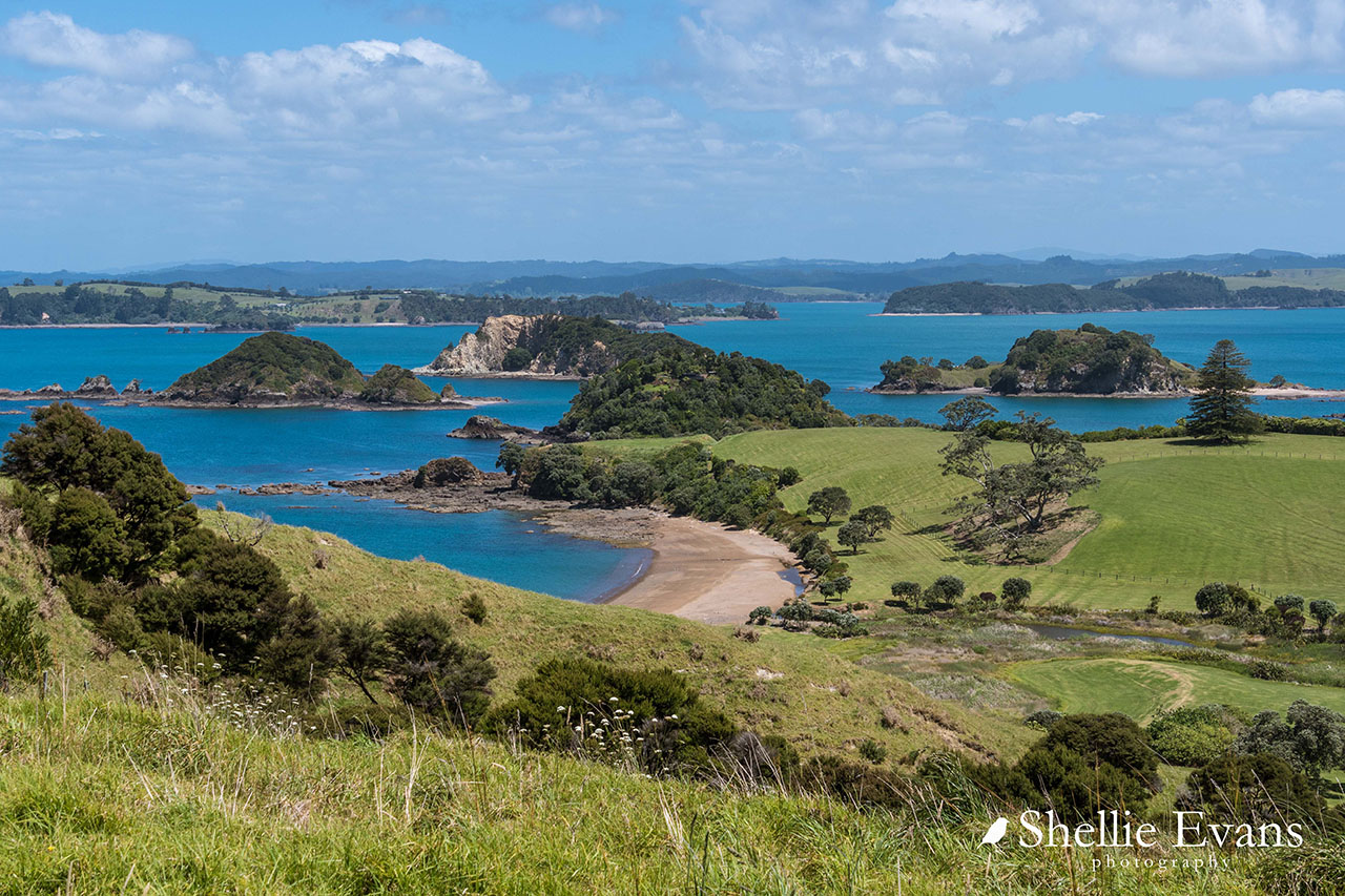
Ngati Torehina consider that their ancestors arrived before the migration of the seven canoes and have lived in the area since that time. Mataka is a Ngati Torehina name for the maunga that overlooks Rangihoua and its adjacent bays. In the very early years of the nineteenth century, the land at Rangihoua and Wairoa Bays was under the control of the Hikutu chief Te Pahi (?-1810), who resided on one of the islands that today bear his name. It is likely that occupation at this time stretched along the foreshore of both bays, with the fertile Te Puna valley containing fields and gardens linked with Rangihoua Pa.
Early contact and trade
Te Pahi's settlement became the most important location in the Bay of Islands and the north for trade between Maori and Pakeha, as a favoured anchorage of English vessels employed in the southern whale fishery. In 1793 two men from Northland, Tuki Tahua and Ngahuruhuru, were kidnapped by the crew of HMS Daedalus, acting on the Governor of New South Wales' suggestion that a native New Zealander might be able to teach the convicts at Norfolk Island the art of flax dressing. The two men returned later in the same year, bearing gifts from the Governor, Philip King, of pigs, potatoes, wheat and maize, as well as carpentry tools, hoes and spades, forming one of the first introductions of European goods into New Zealand. Governor King's deliberate intention was to introduce items for which a demand might grow. Te Pahi saw that the barter of such goods could potentially be beneficial, and was the most prominent chief of the time to pursue such trade. When the first whaling ships arrived in the Bay of Islands in search of supplies, he made conscious efforts to furnish provisions such as wood and water in return for European items of value.
By 1805, Rangihoua was described as 'the capital' of the area, with about one hundred houses, surrounded with gardens, on both the mainland and Te Pahi's island. Potatoes of an excellent quality were grown, which were stored on high platforms or whata, standing on a single post. They were traded with incoming ships for any articles made of metal, especially axes, adzes and hatchets. Some of the earliest Europeans to reside in New Zealand were based at Rangihoua, including the ex-convict George Bruce, who married Te Pahi's daughter Atahoe. Bruce played a pivotal role in Te Pahi's enterprise, acting as interpreter and an agent in trade.
In early 1805, Te Pahi's son Maa-Tara visited the British settlement at Port Jackson (Sydney) to explore the world where such goods originated. Later in the same year, Te Pahi himself travelled to Norfolk Island and Port Jackson to visit Governor King, the earliest prominent chief to do so. On this visit, Te Pahi stayed with King, returning to Rangihoua in February 1806 with tools and other implements from the government store, gifts of goats, pigs and fowl from private individuals, and a pre-fabricated European-style house which the ship's carpenter erected on the island. During this trip, Te Pahi made a strong impression on Samuel Marsden (1765-1838), senior chaplain in New South Wales, who reported that he was 'the first New Zealand chief that I had seen in Port Jackson, and with whom I had formed a particular intimacy'.
In 1808, Te Pahi made a second visit to Port Jackson to learn more about European methods of agriculture and the weaving of linen. While there, he warned the acting governor of the colony, Joseph Foveaux, that the common practice of ill-treating Maori sailors should stop. His advice was not heeded, and in late 1809 the crew of the Boyd was massacred in northern New Zealand as an act of utu by the Whangaroa chief Te Puhi after his brother had been mistreated on board. Early in the following year, a group of whalers and sealers took a bloody revenge on Te Pahi, who appears to have been present at the Boyd incident but not directly involved in the killings. The seamen attacked and looted Te Pahi's island, massacring many of its inhabitants, and although Te Pahi himself managed to swim to the mainland he died soon after of his wounds. After this attack and the ensuing deaths, the island remained tapu. On his first visit to the Bay of Islands in 1814, Samuel Marsden noted his implicit belief in Te Pahi's innocence in the Boyd affair, and lamented his murder:
'I never passed Tippahee's Island without a sigh. It is now desolate, without an inhabitant, and has been ever so since his death. The ruins of his little cottage, built by the kindness of the late Governor King, still remains.'
Missionary activity
Samuel Marsden played an important role in the subsequent history of contact between Maori and Pakeha, having taken up a post as the Pacific representative of the London Missionary Society, a Protestant Christian organisation, in 1804, and persuading the newer Church Missionary Society (CMS) of the virtue of establishing a mission in New Zealand a few years later. His plans to create the first missionary settlement in New Zealand at Rangihoua Bay may have been encouraged by his encounters with Te Pahi, but it was Ruatara (?-1815), Te Pahi's successor at Rangihoua, who enabled him to turn this into reality in 1814. Ruatara lived with Marsden's family at Parramatta in New South Wales prior to 1812, where he learned about European methods of agriculture and planned to export wheat to Port Jackson in return for tools and tradable commodities such as tea and sugar. He is likely to have believed that a mission at Rangihoua would facilitate this process, attracting visiting ships as well as providing a resident supply of skills and materials. In his turn, Marsden sought to create a dependency on missionary skills, hoping to gradually persuade local Maori to listen to his evangelical message.
The missionary settlement was founded during a visit by Marsden himself in December 1814 under the protection of Ruatara and Hongi Hika (1772-1828), another renowned Ngapuhi chief. This was established at the eastern end of Rangihoua Bay at Oihi, a narrow valley dominated by Rangihoua Pa. The pa was evidently the most significant settlement in the Bay at the time, separating the mission from more fertile farmland in the Te Puna valley, where crops for trading were grown. The earliest recorded church service in New Zealand took place at Oihi on Christmas Day 1814. Ruatara planned to build a town on European lines, possibly on a low hill overlooking the Papuke headland at the western end of Rangihoua Bay, but died in early 1815. He and his wife Rahu, who committed suicide after his death, lay in state on the spot of the proposed town before being moved to their final burial place. The role of protector for the mission fell primarily on Hongi Hika, with other chiefs including Waikato, Wharepoaka and Te Uri o Kanae continuing to be closely involved.
While Ruatara was ill in late February 1815, a deed of sale for at least 80 hectares (200 acres) was signed between Te Uri o Kanae and the CMS. Costing twelve axes, the transaction accounted for a block of land bounded by Rangihoua Pa and Bay to the south, Waitohara creek to the north, and a track into the interior to the west. It was the first deed of purchase to be signed in New Zealand, and the missionaries hoped that it would allow them a degree of self-sufficiency. The land obtained, however, proved to be largely unproductive although attempts to grow crops and raise animals nevertheless represent a pioneering attempt to create a European-style farm. The settlers initially shared a single large building at Oihi until individual timber houses for each family, numbering four in 1824, were erected on hillside terraces. A schoolhouse was opened in 1816, with 33 pupils from the pa and the mission station, expanding to 70 by the following year. A cemetery was also established, eventually bearing at least nineteen burials, including those of the missionaries John and Hannah King, several of their children, and a number of seamen from whaling ships.
Skills Maori were taught included reading and writing, as well as practical tasks such as spinning, shoemaking and sewing. The missionaries came from relevant backgrounds and apart from John King, a shoemaker and ropemaker, included William Hall, a carpenter, and Thomas Kendall (?1778-1831), school teacher. The settlement also incorporated King's in-laws, the Hansen family, as well as two sawyers, a blacksmith and Kendall's servant, Richard Stockwell. The latter were convicts who had been given leave to join the mission.
Missionary attempts at farming appear to have been largely unsuccessful, and frustrations within the enterprise grew as Maori traded independently of the CMS with commercial ships anchored in the Bay. In 1819, the CMS established a new mission station at Kerikeri, where Hongi Hika's main pa at Kororipo was located. Rangihoua Pa however continued to be a major source of food for provisioning ships, and in 1830 its population was estimated to still number at least 200. At this time, the tihi of the pa formed the site of prominent Maori burials, including that of Karuhi, Wharepoaka's sister and wife of the early colonial trader, Phillip Tapsell. The Oihi mission nevertheless made some headway in the conversion of local inhabitants to Christianity and carried on in reduced circumstances until 1832, when the missionaries, by now comprising just John King and James Shepherd, and their families, relocated to the more fertile Te Puna valley on the western side of Rangihoua Bay. The land on which this was located had been purchased in 1828 from the chiefs Wharepoaka, Manuwiri, Waikato, Marupainga and Pani in exchange for twelve axes.
Missionary work, including teaching and conducting church services, continued with visits to Maori villages in the area such as Wiriwiri at the eastern end of Wairoa Bay. It also appears that Papuke Pa and its environs were still inhabited by Maori at his time. The Te Puna mission site comprised two mission houses close to Rangihoua Bay. Pakeha settlement elsewhere in the vicinity expanded noticeably through the 1830s, including land purchases of 287 hectares (710 acres) by John King on his own behalf. Thomas Hansen, Hannah King's brother, and his family, also owned a homestead and farm known as 'Kouto', running from the site of Ruatara's proposed town down to the Papuke headland, which had initially been purchased from the chiefs Wharemokaikai and Morenga in 1834. Thomas and Elizabeth Hansen have been referred to as New Zealand's earliest European settlers and were amongst the first Pakeha farmers in the country.
By the 1850s, most of the land at Rangihoua was in Pakeha hands, with the number of Maori living in the area having significantly declined. Relationships were also generally more tense in the colony as a result of increasing competition for land. The Te Puna mission continued to function until the death of John King in 1854, although his son-in-law Richard Davis was still conducting services in the area in 1859. By this time, just 2.4 hectares (6 acres) of land was retained as a Maori reserve at Rangihoua Pa.
Later history
Following the closure of the Te Puna mission, some of the land purchased by the CMS and all of that purchased by King was transferred to King's children in small lots. Their size reflected the scale of much Pakeha tenure in the North Island, where the small farm became the characteristic unit of settler agriculture. Some of his adult offspring continued to live on the mission station site, which was initially retained by Trustees of the CMS but eventually sold to the Hansen family in 1874 for incorporation in their adjacent farm at Kouto. A later nineteenth-century house near the mission site was occupied by Hannah Letheridge, a daughter of Thomas and Elizabeth Hansen, shortly before her death in 1907. Hannah Letheridge was widely considered to have been the first European woman born in New Zealand, although William Hall's daughter had preceded her. The land continued to be remote from the main centres of settler occupation, which lay elsewhere in the Bay of Islands and further afield, and was mostly given over to pasture. During the early 1900s, much of the property owned by King's descendants was purchased by Walter Clapham Mountain (1864-1930), who consolidated it as part of his much larger holdings on the Purerua Peninsula. His lands included the mission station sites at Te Puna, purchased in 1917, and Oihi.
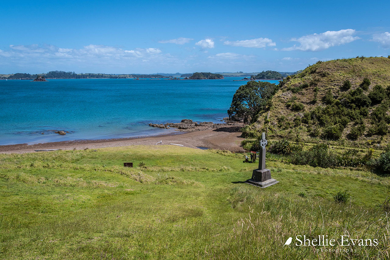
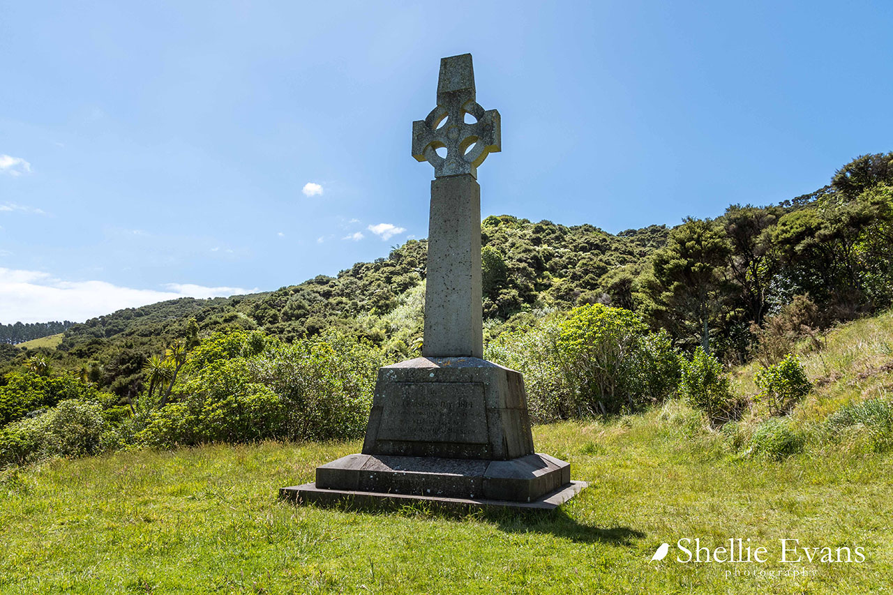
Throughout the later nineteenth century Rangihoua Bay, and Oihi in particular, gained symbolic currency as the birthplace of Christianity in New Zealand. The Reverend John Kinder made a visit in 1864, taking what is probably the earliest photograph of Oihi. In the 1890s, Henry Williams, the son of the missionary leader of the same name, went to the site and removed timber from one of the houses that was still standing, while Archdeacon P. Walsh also visited the Bay on at least two occasions. In 1907, the Marsden Cross was erected overlooking the foreshore, and was unveiled by the Governor-General of New Zealand, Lord Plunket. In December 1914, a service conducted by the Bishop of Auckland, was held next to the monument to commemorate the centenary of the mission's foundation. Following storm damage, a contract was let for a more stable Cross in 1918. State recognition of the mission site was formalised by 1930 with the taking by Crown proclamation of the cemetery at Oihi as a scenic and historic purposes reserve. This coincided with growing national awareness about the value of New Zealand's unique landscape and history. A monument to the King family has also since been erected at Oihi.
Most of the land in the Rangihoua Bay area passed to Walter Clapham Mountain II on his father's death in 1930, and has since mostly been used for cattle grazing. In the 1970s, further land around the Oihi site was transferred to the Crown, creating a significantly larger reserve. Road access to the area was created in the same decade, when a single farm track from the main Purerua Peninsula road was cut through. The privately owned elements of the area, including those currently held by MLP LLC (Mountain Landing Properties) and other bodies are subject to development pressures. In 2003, a large clubhouse was constructed on the Wairoa Flats, at the eastern end of Wairoa Bay, removing the upper parts of the middens on this site. More recently, a house has been built on the ridge forming the eastern boundary of the area.